A Ladywell Walk
Route & what to see
|
|
| london-footprints.co.uk |
A circular walk featuring the Waterlink Way, Brockley & Ladywell Cemetery and Hilly Fields. Also included are buildings from the Lewisham Workhouse (now University Hospital) and Bermondsey Institution. Instructions are given from Ladywell Station but Crofton Park is on the route. The distance is 3.5 miles plus the cemetery circuit.
On exiting the station go up
to Ladywell Road and turn right
The bridge over the railway marks the site of the Holy Well or
Well of Our Lady. This was in existance in 1472 and ran dry in
1855. St Mary's Centre was built in 1891 and extended in 1988.
The former Ladywell Baths were opened in 1884 and last used in
the 1960s. The houses opposite date to 1857 when Ladywell Station
was built. The Coroner's Court was constructed in 1894 and the
former police station in 1899. On the opposite corner Ladywell
House was the vicarage built in 1693 for Dean George Stanhope. It
was extended in 1881 and 1895 and has a fine garden. It was
converted to office use in 1981.
Right into the High Street
The former fire station was built in 1898 and used until 1968.
The Hire Shop opposite includes a building of 1791. Next door is
a house of 1876 and HE Olby occupy premises from the 1930s. The
shops adjacent were originally houses of c1700. The parish church
of St Mary the Virgin was rebuilt in 1777 by George Gibson
retaining the late 15th century tower to which another storey was
added. The chancel was designed by Sir Arthur Blomfield in 1881.
St Mary's School includes the original National School of 1833
and extensions of 1860 including a teacher's house. Colfe's
Almshouses, which were on a site now occupied by the Registry
Office, were replaced by Colfe & Hatcliffe Glebe in 1952.
Alongside is the only remaining house from the Lewisham Park
development of the 1850/60s. The former Lewisham Library
(1901-1994) is now the hospital's education centre. The grassed
areas between the road and the pavement indicate the course of a
tributary of the River Ravensbourne. They are planted with a
number of trees including some walnut and there is an old pump.
University Hospital Lewisham incorporates buildings from the
former Lewisham Workhouse. The Children's Outpatients building
was built as the doctors' quarters of the infirmary in 1895.
Further along the Waterloo block is the oldest part of the
workhouse, constructed in 1817. It was extended in the 1880s and
a separate infirmary for inmates and others was built in the
1890s. During WWI it became a military hospital although there
was some workhouse use until 1929.
Return to the entrance
between the car parks and follow signs to RIVERSIDE.
This is the newest section of the hospital. Alongside is an
open area with a glass sculpture representing the Lady Well.
Cross the bridge into
Ladywell Fields.
These former water meadows were purchased in 1889 to serve as a
public park. They have been re-landscaped to incorporate the
River Ravensbourne in a more natural setting.
Follow the riverside path
(Waterlink Way) to the left. Beyond the children's playground use
the footbridge to cross the railway. Take the path to the right,
signposted to John Evelyn Education Centre.
This occupies the dining hall of the former Bermondsey
Institution, built for the aged and infirm in 1897-1900. The
administration block and superintendant's house either side are
now residential. Behind is a water tower. The institution served
as a military hospital in WWI and was taken over by the LCC in
1930.
Return to and continue along
the riverside path with the river to your right. The path goes
under another railway and over the river. Leave the riverside
path and go along the edge of the field. Go right at Ewhurst Road
and right along Manwood Road. At the end cross Brockley Grove
into Marnock Road.
Crofton Park Station was opened in 1892 on the London, Chatham
& Dover Railway.
Right into Brockley Road
The Rivoli Ballroom opposite was originally a cinema, built in
1913 and extended in 1924. Crofton Park Library was opened in
1905.
Continue along Brockley Road
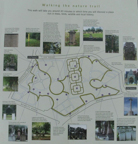
and enter Brockley & Ladywell Cemetery at the corner of Ivy
Road
This was originally two cemeteries both opened in 1858, Deptford
now Brockley and Lewisham, now Ladywell. The dividing wall
between them has been removed. There are many tombs and memorials
of interest and it is a haven for wildlife.
When you have explored the
area exit by the same gate and continue along Brockley Road.
Right into Adelaide Avenue.
The houses of St Margaret's Square on the right were built around
1886.
At the junction with
Montague Avenue take the path going up across Hilly Fields
This became a park in 1896 to save the area from development.
There is an area of managed meadow to the right. The school was
built in 1885 and has since been extended.
Continue between the
playground and the tennis courts
The elevated position gives fine views.
Leave the park by the path
signposted to Ladywell Station.
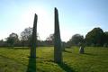
A stone circle which acts as a sundial was constructed for
the Millennium.
Exit the park and go right
down Vicars Hill
There are some attractive late Victorian houses.
Right around Gillian Street.
The Ladywell Tavern was built c1846 and altered c1895.
Cross Ladywell Road into
Slagrove Place.
Here are additional remains of the workhouse opened by Bermondsey
(St Olaves) Union. These comprise the gateway, porter's lodge and
stable block. The Slagrove estate of 1995 replaced the nursery
block.
Return and go right at
Ladywell Road
Numbers 74, 76 & 78 date to the 1830s.
Resources
Discover Deptford & Lewisham by Darrell Spurgeon
Historic images [webpage]
Crofton Park Station [webpage]
Bermondsey Workhouse information [webpage]
Lewisham Workhouse information [webpage]
Friends of Brockley & Ladywell Cemetery [website]
Brockley & Ladywell Cemetery map (95KB) [click here]
Hilly Fields Map [click here]
© london-footprints.co.uk 2010