Route & what to see
|
A Lambeth Walk Route & what to see |
| london-footprints.co.uk |
This 4½ mile circular walk from Waterloo Station uses lesser known streets but passes several attractions which can be visited. Southwark and Lambeth North tube stations are on the route.
Waterloo Station was rebuilt 1900-22 when it was opened by Queen Mary. The main 'Victory Arch' entrance serves as a war memorial to staff killed in WWI. There is a new statue on the concourse of artist Cuneo - Can you find his trademark mouse?
Exit and go through the IMAX
subway
IMAX has the largest cinema screen in the country (20m x 26m)
with exterior walls by Howard Hodgkin. The Schiller International
University is housed in the former Royal Waterloo Hospital for
Children & Women (closed in 1936). First constructed in 1823
it was rebuilt in 1905 in red brick with terracotta dressings and
a ceramic facade.
Go across to St John the
Evangelist Church
One of the 'Waterloo' churches this was built in 1823-4 to the
designs of Francis Bedford. It was bombed in WWII and restored by
Thomas Ford in 1950.
Go along Exton Street then
across Cornwall Road into Roupell Street
These Grade II listed buildings were constructed as workers
houses around 1818. At the end of the street is a former school
and some Peabody Buildings.
Cross Hatfields
As the name implies this was an area of hatmaking.
Continue along Meymott Street
bearing left into Columbo Street
Paris Garden was a small manor dating back to 1113 originally
owned by the Knights Templar. It became Tudor pleasure gardens,
was used for cloth bleaching during the Commonwealth and at the
end of the 17th century was developed with housing.
Walk through the churchyard
Christ Church was built in 1671 and rebuilt in 1738 and 1959,
after WWII bomb damage. The place where the burning cross fell is
marked with stones in the grass. Its stained glass windows depict
Southwark industries. There is a new wildlife garden
Right at Blackfriars Road
There is a distinctive tiled building on the corner with
Nicholson Street. At the junction with Union Street is a new
development designed by Will Alsop. It is worth viewing the
interior of Southwark Station which was constructed on the
Jubilee extension.
Walk along The Cut
The Young Vic Theatre has been re-constructed. It was built on
the site of some bombed shops with the foyer featuring the
tilework from the remaining butcher's. The death of 54 people
following a direct hit on the baker's on the corner of Greet
Street is recorded.
Opposite the theatre go along
Short Street
St Andrew's Church was rebuilt to incorporate flats and
communiy rooms as well as worship space in 2006.
Right into Ufford Street.
These Grade II listed cottages were built around 1900 by the
Church Commissioners. The playground has been improved under an
M&S scheme.
At the end go right into
Webber Street
The OLD VIC opened in 1816 as the Royal Coburg Theatre
and became the Royal Victoria (Music) Hall in 1833. From 1880 it
was transformed into a temperance venue by Emma Cons. Later her
niece Lilian Baylis put on quality drama including Shakespeare
such that it became the home of the National Theatre in 1963-76.
It seats 1067 and was purchased by the Old Vic Theatre Trust for
£3.5m in 1998.
Cross Waterloo Road into
Baylis Road. Go into the Millennium Green on the left.
This is a pleasant public garden with water features.
Walk through and exit into
Waterloo Road
The building opposite was built for the David Grieg Store in
1928. Only the grand facade remains behind which new offices for
the Department of Health were constructed in 1979.
Continue right along Waterloo
Road
There is an attractive children's playground.
Just past this go right along
Pearman Street to the right of the ambulance station. At the end
go right into Westminster Bridge Road.
The Perspective Building at 100 is apartments. Christchurch &
Upton Chapel stands on the site of a female orphanage founded
1758. The 'stars & stripes' pattern on the spire commemorates
donations received from America to build the church in 1873. It
was destroyed by bombing in 1940 but the tower was retained in
the new chapel and office development. Lambeth North Station
features ox-blood tiles.
Right into Baylis Street and
first left around Murphy Street. Left into Frazier Street then
left into Lower Marsh.
This former rural village street is now a conservation area.
There is a plaque on the SW corner.
Left along Westminster Bridge
Road.
Opposite is the Crown & Cushion pub on the site of tea
gardens and the entrance to the former London Necropolis Station.
This special railway service moved from York Road in 1900 and
carried coffins and mourners to Brookwood Cemetery in Surrey
until WWII when the premises were bombed. [read more]
Cross at the junction and go
along Hercules Road.
Flats have replaced Georgian houses which included the home of
William Blake in the 1790s (blue plaque). There are early 19th
century cottages opposite.
Detour right into Centaur
Street.
There is an installation of mosaics depicting the work of William
Blake. There are also sound stations with recordings of his verse
(not much use when the trains are passing overhead!).
Return to and continue along
Hercules Road. At the end go left along Lambeth Road.
There is a blue plaque on number 100 to Captain Bligh, commander
of the 'Bounty'.
Cross St George's Road to the
RC Cathedral.
The building designed by AWN Pugin in 1840-8 was never fully
completed. It was incinerated in a bombing raid of 1941 and
rebuilt from 1953. The stained glass windows have vivid colours.
Cross back to the Imperial War
Museum and go through the main entrance gates.
This is housed in the former Bethlem Royal Hospital for the
insane (Bedlam) which moved here from Moorfields in 1815. When
the institution relocated to Beckenham in 1926 the flanking wings
were demolished. The building is surrounded by the Geraldine Mary
Harmsworth Park which includes a Soviet War Memorial, a section
of the Berlin Wall and the Tibetan Garden of Contemplation and
Peace, opened by the Dalai Lama in 1999.
Walk through the Peace Garden,
exit into St George's Road and go right. Second right into West
Square.
The central garden was laid out in the 1790s when the first
houses were built and has some old mulberry trees. The Admiralty
erected a tower on number 36 for a shutter telegraph that
conveyed messages between Whitehall and naval establishments in
Kent.
Walk through or around the
square and exit via Austral Street.
The former All Saints Hospital is now used by the Imperial War
Museum.
At the end cross Brook Drive
into Sullivan Road then bear right through Walcot Square (which
is triangular!) keeping left of the green.
This was donated to the poor of Lambeth by Edmond Walcot in
1667. The present houses were built in 1837-9 and are now part of
a conservation area. According to Dickens 'Bleak House' Mr Guppy
lived in the square.
Exit into Kennington Road and
go left then first right along Walnut Tree Walk.
This passes Roots & Shoots community garden which offers
training to 16-25 year olds with learning disabilities.
At the end go left along
Lambeth Walk
This is featured in the song/dance from 'Me and My Gal'. Mayhew
recorded 164 costermongers in its market in 1861.
Right at Juxon Street
continuing under the railway around Pratt Walk. Cross Lambeth
Road.
The entrance to Archbishops Park is here. This was created from
land given by the Archbishop in 1900.
Continue along Lambeth Road to
the roundabout.
On the right the Ark occupies the former St Mary's Infants School
of 1880 and includes a garden in the playground. Beyond this the
redundant church of St Mary Lambeth has housed the Garden Museum
since the 1970s. It has stained glass windows to the Trandescants
(Royal Gardeners) and the Lambeth pedlar (a stipulation of his
donation to the church).
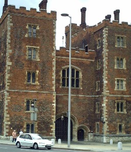
Cross Lambeth Palace Road to
the riverside and walk northwards.
Lambeth Palace has been the official residence of the Archbishop
of Canterbury since the 12th century. The gatehouse was built
c1495 and rebuilt in 1828-34. There are views of the Palace of
Westminster across the river. Further along the riverwalk passes
St Thomas's Hospital rebuilt here in 1868-71 to a design approved
by Florence Nightingale which included the training school for
nurses she established. Only 3 of the original seven pavilions
remain plus the chapel. The north end was rebuilt post-war and
includes the Florence Nightingale Museum. Westminster Bridge was
constructed in 1739-50 and rebuilt to a design by Charles Barry
and Thomas Page in 1854-62.
Use the subway to go under
Westminster Bridge
County Hall was built for the LCC later the GLC (1965-86) in
1911-33 on a site previously occupied by the Coade Stone factory.
It now houses several attractions and places to eat. The London
Eye constructed for the millennium has proved popular with
Londoners and visitors. Up to 15000 passengers a day can travel
in the 32 glass pods rising to 135 metres and giving views up to
25 miles.
It may be possible to walk
through the County Hall building.
This emerges in Belevedere Road with a view of the former
Lying-In Hospital of 1828 in York Road.
Otherwise go to the right through Jubilee Gardens into Belvedere Road and go left.
Access Waterloo Station along Concert Hall Approach just beyond the railway.
© london-footprints.co.uk 2015
[places to visit] [Theatres] [Blue Plaques] [Peabody] [trails] [walks list]