Route & what to see
![]()
|
A Southwark & Borough Walk Route & what to see |
|
london-footprints.co.uk |
A 3½ mile circular walk around Southwark and the Borough. The walk is described from London Bridge Station but Borough tube station is on the route. There is a wide choice of places for refreshments in Borough High Street or pubs on the route. There are several places of interest to visit in the area.
Exit London Bridge Station
into Tooley Street
London Bridge opened in 1836 as the terminus of London's first
railway line. Notice on the corner of Cotton Lane a memorial
plaque to James Braidwood, the Chief Superintendent of the London
Fire Brigade who was killed in the Tooley Street fire of 1861.
Go left along Tooley Street
The London Bridge Hospital occupies buildings of 1903 by Peach
& Reilly. The adjacent building was designed in 1908 by
Adshead for the Bennet Steamship Company. St Olaf House was
designed by H S Goodhart-Rendel for the Hays Wharf Company in
1928-32 as offices & warehousing and replaced St Olave's
Church (1088-1928). Some features, including the alignment of Old
London Bridge, are marked by strips in the pavement. The southern
end of the current bridge is supported on an arch retained from
its predecessor designed by John Rennie in 1831. There are some
light features in the pavements under the bridge. The steps on
the west side are known as Nancy's Steps (from Dickens Oliver
Twist). There are some more stones from old London Bridge in this
area. Until 1905 Southwark Cathedral was the parish church of St
Saviour. It now has an attractive courtyard, refectory and glazed
walkway on this side.
Continue around Montague Close
and go right at Cathedral Street.
St Mary Overie Dock is home to the replica of Drake's Ship the
Golden Hinde.
Go onto the platform alongside
the Thameside Inn for river views.
Make a point of reading the story on the panel at the side of the
dock!
Return to and continue along
the Thames Path
On the left are the 14thC remains of Winchester Palace including
the rose window. A plaque alongside gives more information.
Continue along Clink Street
A warehouse building stands on the site of the Clink Prison. This
prison was closed after the Gordon Riots in 1780.
Go left along Stoney Street
just before this building then right at Park Street and left into
Redcross Way.
Cromwell Buildings on the right, consisting of housing with
integral shops, were erected in 1864 by the Improved Industrial
Dwellings Corporation headed by Sir Sydney Waterlow.
Return to and continue along
Park Street which later bends to the left.
Numbers 20-26 and 21-23 are early 19thC houses. The site to the
left was that of the Anchor Brewery (hence Porter Street). On the
left just before Southwark Bridge is the site of the Globe
Theatre marked in the paving of the development and with a plaque
and information boards. Just beyond the bridge on the right the
remains of the Rose Theatre, excavated in 1989, are preserved in
an office building. Bear Gardens on the right marks the site of a
former bear baiting venue. A warehouse here was used by Sam
Wanamaker as a base from which to operate the project to rebuild
the Globe.
Go right along New Globe Walk.
This passes the Inigo Jones Theatre which will provide an indoor
venue for the company which uses the Globe. It will be renamed
the Sam Wanamaker Theatre when it reopens in 2013/4.
At the end go left along
Bankside.
There are some fine gates to the Globe which depict flora and
fauna mentioned in the plays of Shakespeare (a guide can be
purchased in the shop). Further along is the entrance to the
exhibition and some old buildings of interest. The Millenium
Bridge crosses the river towards St Paul's Cathedral and just
beyond this the popular Tate Modern is housed in the former
Bankside Power Station. Further along is the Bankside Gallery.
Before Blackfriars Bridge go
left and continue along Hopton Street.
Number 61 dates back to 1702. Just beyond this are the attractive
Hopton's Almhouses of 1752.
Cross Southwark Street and
continue along Bear Lane.
There is a view of the rear of the 1877 Kirkaldy Testing Works in
Southwark Street [website].
At the end go right along
Great Suffolk Street, crossing Union Street with care.
Great Suffolk Street was at one time called 'Dirty Lane'.
Go right at Pocock Street and
left into Glass Hill Street
The former Draper's Almhouses were built in 1820.
Return to and continue along
Pocock Street. At the end go right into Sawyer Street.
The fire brigade premises were built on the site of the St
Saviour's Parish Workhouse of 1777 and a hat factory.
Cross Southwark Bridge Road
into Lant Street and go right into Sudrey Street.
The attractive Gable Cottages of 1889 owe their existance to
Octavia Hill.
Return to and continue along
Lant Street.
Charles Dickens lodged here in 1824 whilst his father was in the
Marshalsea Prison (covered later in the walk). The primary school
has been renamed.
Go left into Weller Street.
This is one of several local streets named after Dickens
characters.
At Mint Street go left through
the park into Southwark Bridge Road.
The park site was formerly that of the St George's Parish
Workhouse and later Evelina Children's Hospital now incorporated
into Guy's. Evelina was one of the Rothschild family who died in
childbirth (see plaque). Winchester House of 1820 is occupied by
the Fire Brigade and was their headquarters until the 1930s.
There is a museum on the site (visits chargable and by
appointment only).
Go right at Southwark Bridge
Road and left into Copperfield Street.
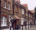
Winchester Cottages of 1893-5 (pictured in header) provided by
the Church Commisioners were inspired by Octavia Hill. The small
park opposite occupies the site of All Hallows Church which was
bombed.
Return to and continue along
Southwark Bridge Road
The Welsh Congregational Chapel dates to 1872-3.
Cross Marshalsea Road and go
through Clennam Street then left along Ayres Street.
This has Octavia Hill houses of 1890 and was previously called
Whitecross Street. It was renamed after Alice Ayres who lost her
life whilst saving 3 children from a fire in Union Street in 1885
(commemorated in Postman's Park).
At the end go right along
Union Street.
This road was laid out to serve the workhouse. There are the
buildings of an education centre on the left and a boy's club on
the right.
Go right along Redcross Way.
The houses set back on the right are part of the group seen in
Ayres Street. They were designed by Elijah Hoole in 1887 and
include a hall with interior decoration by Walter Crane. The
mosaic roundel of The Sower is by James Powell. The garden was
relandscaped by BOST in 2005.
At the end go left along
Marshalsea Road.
This section was previously called Mint Street after a royal
Tudor coin mint in the area. BOROUGH TUBE STATION on the right
was on the first deep underground line of 1890.
Cross to St George the Martyr
Church
This was built in 1734-6 to the designs of John Price and is
known as Little Dorrit's church.
Go northwards along Borough
High Street
This was the Roman Stane Street and has always been one of
London's major streets as it leads to London Bridge, the only
bridge across the Thames until 1750.
Go right into Angel Place
This would have been the site of the Marhalsea Prison (1811-42),
now occupied by the library and local studies centre (see
information plaques). The boundary wall remains on the right.
Return to and continue along
the High Street then go right into Chapel Place.
The Blue-Eyed Maid pub has existed since 1613. The half
timbered building is a Norfolk barn re-sited in the 1980s.
Return to and continue along
the High Street.
Most of the west (left hand) side was demolished for road
widening. There would have been a number of inns along this
street which are recalled by the names of yards on the right. One
of the most famous was the Tabard (re-named Talbot) from which
Chaucer's Canterbury pilgrims set out.
Go right into George Yard.
One side of the galleried coaching inn, a National Trust
property, remains. It was rebuilt after the great fire of
Southwark in 1676.
Return to and continue along
the High Street then go right into St Thomas Street.
St Thomas's Hospital was sited here from about 1215 until 1862
when it was moved for the construction of London Bridge Station.
The church on the left houses the Old Operating Theatre (used
1821-62) in the attic floor. Further along are buildings of the
18thC used by hospital officials. On the right within a courtyard
is the chapel of Guy's Hospital and a statue of its founder
Thomas Guy.
Go left at Joiner Street back into London Bridge Station.
Resources
Southwark Local Studies Library (passed on the route)
has lots of accessable material on the area and publications for
sale.
There is more information on Southwark Prisons and Theatres on
the appropriate walks on this site.
© london-footprints.co.uk 2013
[places to visit] [research] [walks list]