Route & what to see
![]()
|
A Hackney Walk Route & what to see |
|
london-footprints.co.uk |
A 4½ mile walk from Hackney Downs Station (or Hackney Central) finishing at London Fields Station and including visits to Sutton House and Hackney Museum (check open days below). There is the option of continuing to Kingsland Road visiting the Building Exploratory (limited opening).
Exit the station and go right
to the roundabout then right along Amhurst Road, crossing to the
opposite side.
At the end of the road the site of Gibbons furniture store is
being redeveloped. HACKNEY CENTRAL STATION was re-located in 1870
having begun on the site of Bohemia Place opposite.
Go left into Mare Street (the
'Narroway') and cross to the Old Town Hall and church tower.
The Town Hall was built in 1802 to replace the 16th century
Church House and was used until 1866. The 13th century tower of
St Augustine was retained when the church was demolished in 1798
to be replaced by St John's. It is Hackney's oldest building,
purchased by the council in 1929 and since restored. The war
memorial is on the site of the original rectory.
Continue along the Narroway.
Mermaid Fabrics at 364 was formerly a pub. Shoefayre at 387 was
the Manor House of 1845 (marked with a plaque).
Bear right to Lower Clapton
Road
The building on the corner of Clarence Road was Hackney Electric
Theatre (1911-24).
View St John's Church to the
right
This was designed by James Spiller in 1792-7 incorporating
memorials from the old church. The tower and porches were added
in 1812.
Cross Lower Clapton Road to
view Clapton Square
This was laid out in 1811-8. The central garden was opened to the
public in 1923. The east side was demolished in 1943 following
WWII bomb damage.
Continue along Lower Clapton
Road
The police station was built in 1904 and Hackney Baths in 1897.
Follow Lower Clapton Road to
the left
A plaque marks the site of the home of John Howard, prison
reformer. Maitland Place of 1824 was incorporated into the
Salvation Army Mother's Hospital established in the 1890s. This
closed in 1986 and the site was developed as housing.
Continue and cross to Clapton
Pond
Behind this are the Bishop Wood's Almshouses founded in 1665 but
restored in 1888 and 1930. The 19thc chapel has pews only for the
10 resident widows.
Return along Lower Clapton
Road
Clapton School in Laura Place was built in 1914-6 with later
additions
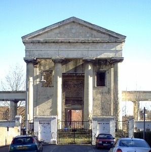
Go left into Linscott Road
The portico is the remains of the London Orphan Asylum built in
1823-5 on the site of a school. The Salvation Army occupied the
building from 1881 creating the Congress Hall seating 4700. When
they vacated it in 1970 most of the structure was demolished but
the portico has been incoroporated into a new building.
Return to and continue along
Lower Clapton Road
The Round Chapel, designed by Henry Fuller, opened in 1871 and
seated 1200. The Grade II* listed building, owned by Hackney
Historic Buildings Trust, is no longer used as a church as
Clapton Park URC occupies restored school buildings. The Sunday
School was added by James Cubitt in 1887.
Continue into Urswick Road
The 1924 Art Deco building on the right was an Electricity
showroom (now flats). Sutton Square is on the site of the Metal
Box Company's former factory.
Cross to Sutton House
Parts of this date to the early 16th century but it has had many
alterations and uses. It was home to Thomas Sutton, founder of
Charterhouse 1602-11. It was acquired by the National Trust in
1938 and is now open to the public (see below).
Go along Sutton Place (1808)
and left at Churchwell Path passing under railway. Cross Morning
Lane and continue along Chatham Place.
Burberry have a factory and shop on the right.
Follow Meeting Field Path to
the left keeping left of the church
St Luke's Church was built in 1871-2.
At the end go right into
Morning Lane then first right along Stevens Avenue
Terraces of late Victorian houses remain.
At the end go left along
Retreat Place and right into Morning Lane continuing along Kenton
Road (to the right of the pub)
The Kenton Arms was built in 1862.
Go left into Cassland Road to
view the school.
South Hackney Upper School was designed for the LSB in 1902 by TJ
Bailey in a Wrenaissance style.
Return to the junction and
walk along the edge of Well Street Common following Meynell Road
then Meynell Crescent
Houses here were built in the 1890s. The garden suburb style
houses in Meynell Gardens to the right were built in 1932-3 by A
Savill on the site of a 18thc mansion.
Right into Church Crescent
To the left is St John of Jerusalem Church of 1845-8 by E C
Hakewill. In 1669 Henry Monger left money for almshouses and
annuities for six poor men over 60. These were rebuilt in 1847
and modernised in 1969. Unfortunately the plaque is unreadable.
At the end of the road is the Hampden Baptist Chapel of 1847.
Right into Terrace Road then
right along Cassland Road.
The terrace of houses on the right was built in 1792 and features
a pediment with Coade Stone decoration.
Just past the crescent go left along Poole Road. At the end go left into Well Street then right along Collent Street
Left at Cresset Road, right
along Mead Place, then left at Retreat Place. Continue along
Paragon Road opposite
The distinctive houses were built in 1810-3. At the end on the
left is a former ambulance station.
Right into Valette Street
The flats were constructed by the LCC in 1906-7. Hackney Trades
Hall was built in 1912.
The road emerges into Mare
Street
Opposite are the Old Ship pub and the restored Hackney Empire
designed by Frank Matcham in 1901.
Go left along Mare Street
On the left are the former Central Hall Wesleyan Methodist
Mission (1924) and the Carnegie Library (1907) now Ocean venue.
Opposite the new Town Hall of 1934-6 by Lanchester & Lodge
retains original furnishings and light fittings. The gardens in
front were the site of the previous town hall built in 1866. The
Hackney Museum is housed in a new building on the corner of
Reading Lane.
Continue along Mare Street
then go left into Brenthouse Road
Hackney Synagogue was built in 1896 and enlarged in 1936.
Go through Lyme Grove to the
right
The Pilgrim Lodge is an almshouse of 1865 by A R Pite
Go through St Thomas's Square
to the right and continue along Mare Street
St Thomas's Square is a former burial ground. Just past this is
the London College of Fashion. The building occupied by the
Lansdowne Club at number 195 was built in 1720. It served as the
Elizabeth Fry Refuge (for women ex-prisoners) 1860-1913.
Go right at Lamb Lane. London Fields Station is in Mentmore Terrace to the right
For the route extension
continue under the railway.
The Ragstone house of 1873 was the vicarage of St Michael
& All Angels Church
Continue ahead across London
Fields then bear left and go along Shrubland Road. Bear right
into Albion Drive.
The former Albion pub is now an attractive house.
Cross Queensbridge Road
The Building Exploratory is housed in the school building on the
right.
Continue along Albion Drive through Albion Square (1846-9). At the end go to the right alongside Stonebridge Gardens towards the railway bridge. Follow this road into the main (Kingsland) Road for buses.
VISITS
THE BUILDING EXPLORATORY Albion Drive E8 4ET.
Tel 020 7275 8555 ![]()
A hands-on exhibition designed to help communities understand and
appreciate their local area. Open Thu & Fri 1-5:30 by
appointment.
HACKNEY MUSEUM Reading Lane E8 1GQ. Tel 020 8356 3500. ![]()
Permanent displays and changing exhibitions with events programme
(mailing list available). Open Tue - Sat.
SUTTON HOUSE (National Trust) 2 & 4 Homerton High Street E9
6JQ. Tel 020 8986 2264. ![]()
A Tudor house that has been home to royal courtiers to squatters,
all leaving their mark. Parts of the house including historic
rooms (charge), gallery, cafe and shop open Thu - Sun 12-4:30.
Closed mid-December to end January. Programme of events.
Resources
Historic Hackney circular walk - the Friends of Hackney
Archives
From Tower to Tower Block the buildings of Hackney - Hackney
Society publication
Buildings of England - London 4:North by Cherry & Pevnser
© london-footprints.co.uk 2006
[almshouses] [Art Deco] [walks list]